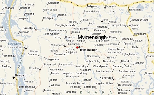
Mymensingh
is one of the districts of Dhaka division, Bangladesh, and is bordered on the
north by Meghalaya state of India and Garo Hills, on the south by Gazipur
district, on the east by districts of Netrokona and Kishoreganj, and on the
west by districts of Sherpur, Jamalpur and Tangail. Mymensingh town is the
district headquarters.
The district covers an area of around 4,363
square kilometers, with several small valleys between high forests. The
temperature ranges from 33 degrees to 12 degrees Celsius, and the annual rainfall
averages 2,174 mm. In fact, Iswarganj is a small upozilla (section) other
upozillas some are at the foot of Garo hills of Meghalaya, some are Chars
founded on the bed of Old Brahmaputra river and also some ancient forests of
mainly a single wood tree as it is named SHAL Forest. The city of Mymensingh
stands on the bank of Old Brahmaputra river, as the 1897 great Assam Bengal
earthquake changed the main flow from Brahmaputra to the Jamuna river which
co-sided west of the greater Mymensingh region. In about hundred years, a port
city of sea vessels from England just lost its status as the river became a
seasonal flow by this time. Some Kuthi's of namely of the colonial rulers
now-a-days the govt. High officials residences along the side of the river in
the city. The area of Greater Mymensingh, the north front line is just at the
foot of Garo hills of Meghalaya of India, the south this area excludes The
GAZIPUR district, the east ends in the rich watery land of Bangladesh as native
calls 'Hawor', the west ends in the ancient single wood forest(e.g. Muktagacha,
Fulbaria and Valuka Upozillas) and the Chars of Jamalpur district sided
north-west of Mymensingh district. There is geographical varieties comprises
single wood forests, Chars and river valleys and also touching the Himalaya at
Garo Hills.
Maimansingh,
a district of British India, is in the Dhaka division of Eastern Bengal and
Assam. It occupies a portion of the alluvial valley of the Brahmaputra east of
the main channel (called the Jamuna) and north of Dacca. The administrative
headquarters are at Nasirabad, usually called Mymensingh town. Area,
6332 sq mi Pop. (1901) 3,915,068, showing an increase of 12.8% in the
decade. The district is for the most part level and open, covered with
well-cultivated fields, and intersected by numerous rivers.
The
district was acquired by the East India Company with the Dewani Grant
from the Mughal Emperor in 1765. At that time its greater part was included in
the Niabat (Sub-Province of Dhaka and a small portion in the Zamindaries of
Atia, Kagmari, Pukuria and Patilandaha (of Rahahahi Zamindari). At the time of
Permanent Settlement, it included northwest Garo-Hills and the Brahmandaria Subdivision
of the Present Comilla district but did not include north Tangail and
north-west part of Jamalpur. In 1799 Taluk Amirabad was transferred to Tippera
(comilla). In 1809, Patiladaha, situated north-east of the Brahmaputra came to
district form Rangpur. In 1811, the river Banar and Brahmaputra were declared
boundary between Dhaka and Mymensingh district and the river Brahmaputra and
Meghna as boundary between Tippera (now Comilla) and Mymensingh and Dhaka. In
1811 west Gar-Hills were transferred to Rangpur district. In 1812 Patiladaha,
was retransferred to Rangpur. In 1830, Parganas Sarail, Daudpur, haripur,
Bejra, and Satarakhandal, were transferred to Tippera and Public convenience.
In 1855, due to change in river course part or Serajganj thana was transferred
from Mymensingh to Pabna and in 1866, the whole of it was transferred to Pabna.
In 1866, thana Dewangajn was transferred to Mymensingh form Bogra and thana
Atia from Dhaka. In 1867 for the administrative convenience boundaries of five
subdivisions (including Tangail) and thanaswere notified. In 1874 on the basis
of survey, the district boundaries were notified. In 1874 the Jamuna (or
Daokoba) River was declared the western boundary between Mymensingh and Bogra
and as such, 165 villages were transferred to Bogra. In 1875, the Brahmaputra
was Made the boundary between Mymensingh and Rangpur and the portion of patiladaha,
east of the river, was transferred to this district form Rangpur. In 1877, the
Jamuna was declared the boundary between Pabna and Mymensingh, in the west. On
the first of December, 1969, Tangail subdivision was separated from Mymensingh
and a new District of Tangail was formed.


No comments:
Post a Comment